2.4. Tisa region - Tisa
Tisa region includes areas - oasis, of east Backa and west Banat, in the area of the river Tisa. it extends from Kanjiza on north to delta of the river Tisa in Danube on south, and includes parts of the territories of municipalities of Kanjiza, Novi Knezevac, Senta, Coka, Ada, Becej, Novi Bečej, Zabalj, Zrenjanin and Titel.
GALLERY
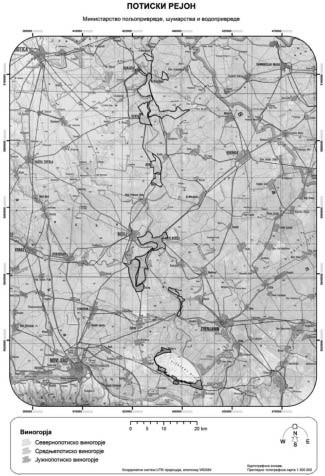
Tisa region goes from 46° 06' geographic latitude on north (most north oasis of the North Tisa vineyards) to 45° 11' geographic latitude on the south (the most south point of the South Tisa vineyards ), at altitudes of 70 m to 100 m, except in south part (Titelski breg) where altitude is a little greater.
Types of soil of this region are chernozem and fluvisol, and more rare humofluvisol and semigley, as well as other types of soil.
Topographic – relief characteristics of the region are low land areas of Pannonia plains. On south of the region there is hill Titelski breg which is 18 km long, whose highest point is 128 m high. In the area of the region there are mostly misty and flood forests of Turkey oak, alder, ash, willow, poplar, and other, as well as pannonian - pontic forest - steppe areas. Landscape characteristics of this region are arable crops, river Tisa with its creeks, and canal Danube - Tisa - Danube (DTD).
Tisa region has the following vineyards:
2.4.1. North Tisa vineyards - Gornja Tisa,
2.4.2. Central Tisa vineyards - Srednje Potisje, and
2.4.3. South Tisa vineyards - Donja Tisa.