1.12. Belgrade region - Belgrade
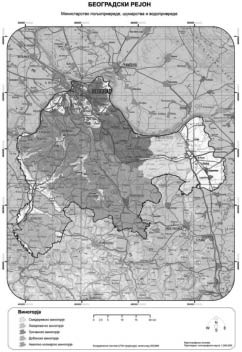
Belgrade region includes south banks of the rivers Sava and Danube, starting at the delta of river Kolubara in Sava (at Obrenovac), and ending at delta of the river Velika Morava in Danube. Region includes area on the slopes of mountains Avala and Kosmaj.
GALLERY
It expands from 44° 50' geographic latitude on the north, to 44° 15' geographic latitude on the south, on altitudes from 100 m to 300 m. Area where vineyards are mostly grown are at altitudes from 150 m to 250 m. Altitude gradually decreases starting from the central part of the region, and toward edges. Exception is south west part with higher altitudes.
Region is mostly characterized by moderate - steep to gentle slopes of the terrain where vineyards are. as well as different expositions. Vineyards are mostly grown on south, south east, and east expositions. Type of soil of this region is eutaric cambisol, though there are also fluvisol, humofluvisol and semigley, luvisol and soils in leaching, pseudogley, chernozem, and other soils.
Belgrade region includes terrain in the municipalities of Obrenovac, Cukarica, Savski venac, Stari Grad, Vracar, Zvezdara, Palilula, Rakovica, Vozdovac, Grocka, Barajevo, Sopot, Mladenovac, Lazarevac and Smederevo.
On the north, border of the region starts at delta of the river Kolubara in Sava, follows the right bank of the river Sava to its delta in Danube. Then it follows the right bank of the river Danube to delta of Velika Morava in Danube. From delta, border goes south along the river Velika Morava, up to the limits of municipalities of Smederevo and Velika Plana (border of cadastral municipality of Saraorci). Further, border goes west along the limits of these municipals, and border of municipals of Smederevo and Smederevska Palanka all the way to border of municipality of Mladenovac and Smederevska Palanka, then Mladenovac and Topola, Mladenovac and Arandjelovac, Sopot and Arandjelovac, Lazarevac - Arandjelovac, Lazarevac - Ljig, then to north along the border of the municipals of Lazarevac - Lajkovac, Lazarevac - Ub, Obrenovac - Ub to the river Kolubara and along the Kolubara basin until is flows into river Sava, where the region starts.
Low mountain Avala (506 m) is located in the region, as well as mountain Kosmaj (626 m) in its south part.
Landscape is characterized by lowland-hilly relief where in lower parts of the region mostly forests of red oak, alder, ash, willow are found. and in higher area forests of common oak, Turkey oak, and other. Landscape consist of hilly terrain, slopes toward rivers are characterized by vast shallows, orchards (especially in Grocka vineyards), and plots with arable crops.
Diffuse radiation has high impact on faster ripening of the grapes, and during winter temperature drops are less frequent (which lowers danger of winter frost); that is because of the river Danube that flows through the north side of the region, and river Sava that flows through the north west side of the region.
Along with these two rivers, region is characterized by a number of smaller rivers, river Velika Morava on the east side of the region, river Ralja flowing through the region, rivers Ljig and Kolubara on south west and west side of the region.
Belgrade region does not include:
- forest complex of Lipovacka Suma in the cadastral municipalities of Barajevo, Sremcica and Meljak,
- forest complex on the mountain Kosmaj in the cadastral municipality of Rogac, Nemenikuce, Koracica and Velika Ivanca, and
- forest complex between mountains Avala and Kosmaj, in cadastral municipalities of Stojnik, Babe, Guberevac, Lisovic, Barajevo, Parcani and Ripanj.
Belgrade region includes the following vineyards:
1.12.1. Avala - Kosmaj vineyards - Avala;
1.12.2. Grocka vineyards - Grocka;
1.12.3. Smederevo vineyards - Smederevo;
1.12.4. Dubona vineyards - Dubona;
1.12.5. Lazarevac vineyards - Lazarevac.